


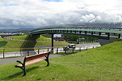
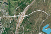
Road and Street Design
VSO Consulting employs the most modern type of design software to increase productivity in the design of roads and streets. Three-dimensional land models are constructed, based on orthorectified aerial photographs, and corrected as needed according to more detailed land measurements. All design is saved in a special database where it can be kept track of and merged with various data, used for drawing cross sections, calculating quantities, etc. One of the biggest advantages of these new software applications, however, is how easy and convenient it is to change a design and drawings and recalculate quantities.
It is commonest, in parallel with the design of streets, to design all of the drainage conduits; in addition, height and measurement sheets are made of plats.
In municipalities outside Reykjavík, it is also common for the water utility’s distribution system to be part of street design.
Among VSO’s projects in the field of road and street design are:
- Grafarholtshverfi neighbourhood in Reykjavik
- Stadahverfi neighbourhood in Reykjavik
- Various residential neighbourhoods and streets in Bessastadir Parish
- Various residential neighbourhoods and streets in Sandgerdi
- Various residential neighbourhoods and streets in Vatnsleysuströnd Parish (Vogar)
- Reynisvatnsás in Reykjavik
- West Fjords Road through Dalafjall (Brattabrekka)
- Arnarnes Road Reykjanesbraut-Breidholtsbraut
- Ring Road Víkurbraut-Skarhólabraut
For further information, please contact Vilhjálmur Árni Ásgeirsson